


 The map shows distribution of the chestnut (Castanea sativa) – one of the rare and relic forest species in the Caucasus region. It is noticeable that all boubdaries of the species’ areal are determined predominantly by climatic factors such as dryness and low temperatures in winter (Sokolov et al. 1977).
 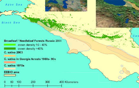 Therefore it can be assumed that the boundaries will change accordingly with the climate changes in Caucasius region. Because of the intensive anthropogenic pressure (agriculture and cutting) chesnut has been included in the regional
  Red Data books. (e.g. http://azecology.org/fce). Download the map in PDF: castanea_sativa_v2.pdf The following materials have been used for the map compilation
- 1. Map of the forests of the Russian Federation (2004) http://forestforum.ru/info/pictures/rusmap.pdf 2. Castanea sativa – the distribution map, including both natural and naturalized occurence. Compiled by members of the EUFORGEN Noble Harwood Network. Published in: Fernandez-Lopez J. and R. Alia. 2003. EUFORGEN Technical Guidelines for genetic conservation and use for chesnut (Castanea sativa). International Plant Genetic Resources Institute, Rome, Italy. 6 pages http://www.ipgri.ogiar.org/networks/euforgen/species 3. Wood species map. Georgia. http://enrin.grida.no/biodiv/ru/national/georgia/State/forest.htm 4. Sokolov S.Y., et al. (1977) Alrealy derevyev i kustarnikov SSSR. (Areals of Trees and Shrubs of the USSR (in Russian). Leningrad: Nauka.EEBIO
Text by: Olexiy Kalynychenko Map compilers: Olexiy Kalynychenko, Vasyl Prydatko (ULRMC), 2006.

0 Comments