


 Pedunculate Oak (Quercus robur): Climate Change and Cartographical and GLM-distribution Modelling by 2030 and 2050
Case-research #1
The model is published with the assistance of ULRMC, funded by ‘Projection of Species- and Species-Climate Based Models on to the GLOBIO Ukraine Region, and Scenarios Development’ Project according to the Contract Е/555050/01/МО (2006) between The Netherlands Environmental Assessment Agency (MNP, Bilthoven) and International Association ‘Ukrainian Land and Resource Management Center’ (ULRMC, Kyiv).
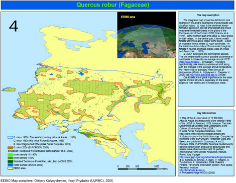
Quercus robur (Fagaceae) – current and predicted distribution modelling
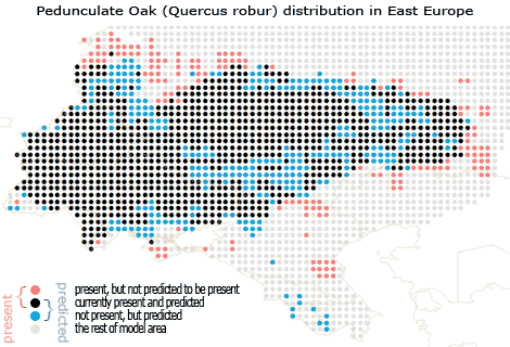

The table shows a difference: ‘current distribution’ contrary to ‘predicted distribution’ by the model (based on climatу change data i.e. GLM-scenario). 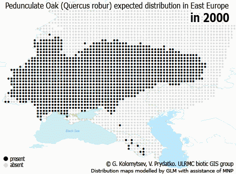 The map shows expected changes in distribution of Q. robur by 2050 due to well known climate changes. Map visualizes a shift of expected potentially-suitable-habitats of the species to the north. The model is based on GLM method and R-statistics. The basic climate change data is derived from an IMAGE model package. The integrated distribution map was compiled with usage of data from local sources of the information as well as the Flora Europaea Atlas map. Map authorы: G.Kolomytsev (IZ NASU), V.Prydatko (ULRMC. Published on: May 12, 2008. Last updated on: May 1, 2009.
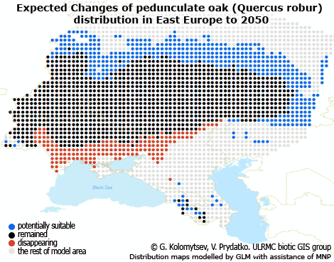
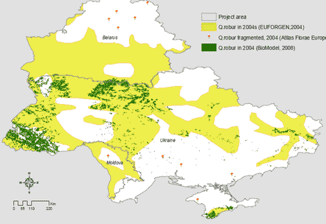
Case-research #2
Quercus robur (Fagaceae): overlap modelling expected natural habitats in Ukraine and Belarus in 2004s’ based on RS- and GIS-analyze,and new GSF data
 Download the map quercus_robur_2004s.pdf
The map explains better what digital data was selected by the BioModel Group for further GLM procedures for the purposes of GLOBIO#4 development. Deep-green colour show real forest plots of all types and that is based on ULRMC’s Landsat data of 1998-2000 (Yu.Shtepa, personal inf.) It intersected well all 0.5-km buffers around of 1735 settlements were referred to Q.robur in scope of 2004. (The respective settlements were found automatically with usage of a know-how software ‘GSF” made in ULRMC ). The map proves that the previous publications did not use realistic data about location of the forested areas in Ukraine in 1998-2004, but a virtual data. Map author: V.Prydatko (ULRMC, NAU). Last update: April 21, 2008.
Case-research #3
Quercus robur (Fagaceae): historical overlap modelling of the habitats distribution in EEBIO Project area 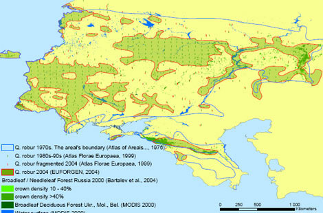 The integrated map (Case-research #3) shows distribution and changes of boundaries of the areal of pedunculate oak (Quercus robur). The tree – Q. robur – is a dominant of forest- formative species in area of broadleaf- and mixed-needleleaf-broadleaf forests in the European part of the former USSR (Sokolov et al. 1977). In the northern part of its areal Q. robur grows in river valleys. In the central part, it forms mixed forests with Picea abies; closer to the south – a belt of broadleaved forests where Q. robur dominates. At the areal’s south boundary it forms small (marginal) forests in ravines and flood-plains (Atlas of Areals and Resources… , 1976). Q. robur belongs to the thermophilic species. The low temperature bound of possible occurrence of oak forests is marked by an average annual of 2?C (http://www.forest.ru – in Russian). Therefore, hypothetically, the oak’s areal boundaries will shift along with the changes in the average annual temperature. For Yearly map of averaged mean annual air temperature (Afonin A., Lipiyaynen K., Tsepelev V., 2005) see http://www.agroatlas.spb.ru Climate. Oak forests are of great importance for the water regime and soil structure, especially on the steep slopes of river valleys and in forest-poor areas.
 Download: quercus_robur.pdf

References
1. Map of the Q. robur areal (1:17 000 000) Atlas of Areals and Resources of the Medical Plants of the USSR (in Russian), 1976. Moscow: The main Department of Geodesy and Cartography at the Cabinet of Ministries of the USSR. 2. Atlas Florae Europaea Database, 1999 – http://www.fmnh.helsinki.fi/english/botany/afe/ 3. Quercus robur – the distribution map. Compiled by members of the EUFORGEN Temperate Oaks and Beech and published in: Ducousso, A and S. Bordacs. 2004. EUFORGEN Technical Guidelines for genetic conservation and use for pedunculate and sessile oaks (Quercus robur and Q. petrae). International Plant Genetic Resources Institute, Rome, Italy. 6 pages http://www.ipgri.cgiar.org/networks/euforgen*species 4. S. Bartalev, D. Ershov, A. Isaev, P. Potapov, S. Turubanova, A. Yaroshenko, 2004. Russia’s Forests. TerraNorte Information System. RAS Space Research Institute – http://terranorte.iki.rssi.ru 5. Processed image MODIS (2000) The text author: Olexiy Kalynychenko (2006). Map compilers: Olexiy Kalynychenko, Vasyl Prydatko (ULRMC), 2006.