


 Animated modelling of A. alces areal in the GLOBIO Ukraine Region (1928-2008) was based on: i) historical maps, ii) reconstructed forest coverage of 1928s, iii) remote sensing data of 2000s. The Step#2 forestall a GLM modelling stage i.e. Step#3. Sources of information for the model: 1) Map of the USSR European Part Vegetation, M1:4, 000, 000, drawn up by Prof. J.Kuznetsov (1928) – in Russian. The map was granted by the Vernadsky National Library (Kyiv). Vectorization made by V.Prydatko, A.Ischuk, Y.Apetova, A.Kalynychenko (ULRMC). 2) USSR Forest Atlas (1973)/Forest Game Birds and Animals – in Russian, granted by the Vernadsky National Library (Kyiv); vectorization by V.Prydatko, A.Ischuk, A.Kalynychenko (ULRMC). 3) BioDAT (in Russian) – www.biodat.ru, prepared by A.Puzachenko; 4) Russian Federation Mammals (in Russian) – www.sevin.ru, prepared by B.Sheftel; 5) Data of the Ukraine State Statistics Committee;6) Terra MODIS (2000);7)ULRMC Data on forested areas in Ukraine in 1990s and 2000s based on Landsat;8)GSF Index data on areal of the species in 19970s and in 2007 (Prydatko pers. inf.);9) ULRMC algorithm on A.alces habitats modelling.
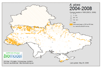
The integrated map shows probable changes of the species area (expansion to the North and South) during the last 80 years because of serious forest area changes (fragmentation), infrastructure and human pressures, and climate change.
Note: two of last animals were short dead by poachers in Cherkassy region of Ukraine in March, 2011.
GIS Map authors: V.Prydatko (ULRMC), G.Kolomytsev (IZ NASU) and A.Kozlova (CASR NASU).
More details about previous EEBIO Project and current GLOBIO: https://biomodel.info/?page_id=93
0 Comments